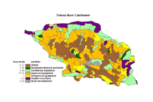
Within the Tarland catchment there are a range of pressures arising from the way in which the land is used. These pressures can lead to flooding, loss of habitat and poor water quality in terms of nutrient and sediment content and microbial contaminants.
Many of these issues are common across much of rural Scotland and indeed Europe . The main contributing factors are:-
- Agricultural runoff
- Wastewater from sewage treatment plants and septic tanks
- Intensive land-use
- Expanding population
Improved land drainage and the canalisation of the Tarland Burn have compromised the catchments ability to slowly absorb rainfall. As a result, river levels can rise rapidly during extreme wet weather resulting in flooding. Intensive land use can lead to elevated levels of silt and nutrients in surface water run-off. Where land is worked right up to burn banks, the buffering capacity afforded by the natural riparian vegetation is lost, as is the protection it would offer in the form of cover for animals living in and around the watercourse. Consequently, the poorer water quality and loss of habitat means that sections of the Tarland Burn and its tributaries are less able to support the diverse ecosystems typical of watercourses in the region.
A number of measures are being implemented to reduce these pressures and improve the environment of the Tarland catchment. Read more about the objectives of the 3Dee Vision project in the Tarland catchment here.
Click here to see real-time water quality and river level data from the Tarland Burn monitoring station.