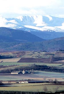
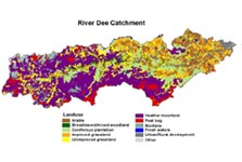
The catchment can be divided into an upland and a lowland region with some 60% of the total area being above an altitude of 300m. The western upland area is classed as moorland, made up of a mosaic of blanket bog and heather moorland, with montane vegetation on the high summits of the Cairngorm Mountains. Forest mainly covers the river valleys of this region, including a high proportion of the few remaining areas of semi-natural ‘Caledonian’ pine woods.
The eastern lowland is dominated by arable farmland and improved pasture and is the focus of the 3 Dee Vision Project.
Select this link to see a land use map of the Dee catchment.
As a water resource, the river is faced with growing pressure as the local population and the demand for water increase. This has also lead to an increase in the domestic sewage effluent which, directly or indirectly, is discharged into the Dee after treatment.
Water abstraction for public drinking water and industrial use, at Invercannie, near Banchory is considered to be a significant issue within the catchment. Other issues include diffuse pollution from forestry and agriculture and various inputs of treated sewage effluent from wastewater treatment works and from septic tanks not discharging to soak-aways. Seven of Deeside’s villages are in the process of receiving upgraded wastewater treatment works to improve the quality of treated wastewater discharging from the larger settlements.
All of these issues will be addressed in the Dee Catchment Management Plan which is currently being developed. The plan will include objectives and agreed actions to alleviate the pressures in specified areas. It is hoped that the work of the 3 Dee Vision Project will contribute towards informing useful approaches to some of these issues.